Property Record
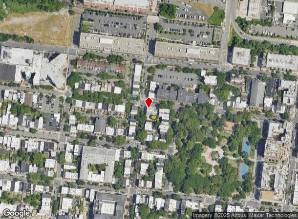
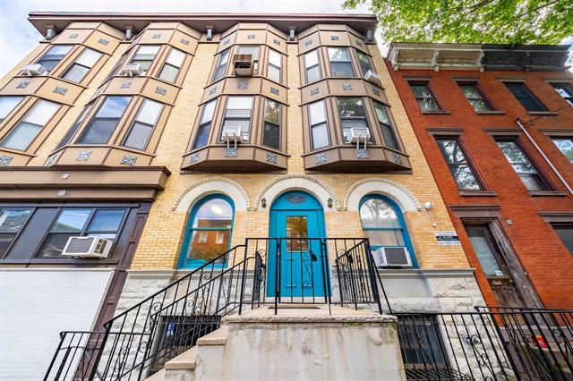
168 Coles St, Jersey City, NJ 07302

This Property Is For Sale
NEARBY LISTINGS FOR SALE OR LEASE
Property Detail
168 Coles St
New York-Jersey City-White Plains, NY-NJ
Coles Street Condo
06-10002-0000-00024-0000-C7001
Hudson
Sfr
New Jersey
AE
0.08 AC
34013C0200F
Hudson Waterfront
1,226 SF
Northern New Jersey
DEMOGRAPHICS near 168 Coles St
1 Mile
3 Mile
5 Mile
2024 Total Population
120,676
629,725
1,582,200
2029 Population
119,997
600,503
1,500,902
Pop Growth 2024-2029
(0.56%)
(4.64%)
(5.14%)
Average Age
36
38
39
2024 Total Households
56,229
286,623
738,832
HH Growth 2024-2029
(0.83%)
(5.00%)
(5.55%)
Median Household Inc
$122,328
$106,564
$102,630
Avg Household Size
2.10
2.10
2.00
2024 Avg HH Vehicles
1.00
1.00
.00
Median Home Value
$728,049
$793,551
$844,806
Median Year Built
1994
1960
1961
Nearby Places
- Restaurants
- Banks
- Shops
- Fitness
- Groceries
PUBLIC TRANSPORTATION
TRANSIT/SUBWAY
Pavonia Newport (22nd Street-Hoboken Terminal - Hudson-Bergen Light Rail (Hudson-Bergen Light Rail), West Side Avenue-Tonnelle Avenue - Hudson-Bergen Light Rail (Hudson-Bergen Light Rail))
DRIVE
WALK
Distance
Pavonia Newport (22nd Street-Hoboken Terminal - Hudson-Bergen Light Rail (Hudson-Bergen Light Rail), West Side Avenue-Tonnelle Avenue - Hudson-Bergen Light Rail (Hudson-Bergen Light Rail))
3 min
12 min
0.6 mi
Harsimus Cove (22nd Street-Hoboken Terminal - Hudson-Bergen Light Rail (Hudson-Bergen Light Rail), West Side Avenue-Tonnelle Avenue - Hudson-Bergen Light Rail (Hudson-Bergen Light Rail))
DRIVE
WALK
Distance
Harsimus Cove (22nd Street-Hoboken Terminal - Hudson-Bergen Light Rail (Hudson-Bergen Light Rail), West Side Avenue-Tonnelle Avenue - Hudson-Bergen Light Rail (Hudson-Bergen Light Rail))
3 min
15 min
0.8 mi
2Nd Street (Tonnelle Avenue-Hoboken Terminal - Hudson-Bergen Light Rail (Hudson-Bergen Light Rail), West Side Avenue-Tonnelle Avenue - Hudson-Bergen Light Rail (Hudson-Bergen Light Rail))
DRIVE
WALK
Distance
2Nd Street (Tonnelle Avenue-Hoboken Terminal - Hudson-Bergen Light Rail (Hudson-Bergen Light Rail), West Side Avenue-Tonnelle Avenue - Hudson-Bergen Light Rail (Hudson-Bergen Light Rail))
4 min
20 min
1.1 mi
Jersey Avenue (22nd Street-Hoboken Terminal - Hudson-Bergen Light Rail (Hudson-Bergen Light Rail), West Side Avenue-Tonnelle Avenue - Hudson-Bergen Light Rail (Hudson-Bergen Light Rail))
DRIVE
WALK
Distance
Jersey Avenue (22nd Street-Hoboken Terminal - Hudson-Bergen Light Rail (Hudson-Bergen Light Rail), West Side Avenue-Tonnelle Avenue - Hudson-Bergen Light Rail (Hudson-Bergen Light Rail))
4 min
20 min
1.1 mi
COMMUTER RAIL
Pavonia/Newport (Hoboken-World Trade Center - Port Authority Trans-Hudson (PATH), Journal Square-33rd Street - Port Authority Trans-Hudson (PATH))
DRIVE
WALK
Distance
Pavonia/Newport (Hoboken-World Trade Center - Port Authority Trans-Hudson (PATH), Journal Square-33rd Street - Port Authority Trans-Hudson (PATH))
3 min
14 min
0.8 mi
Grove Street (Journal Square-33rd Street - Port Authority Trans-Hudson (PATH), Newark Penn Station-World Trade Center - Port Authority Trans-Hudson (PATH))
DRIVE
WALK
Distance
Grove Street (Journal Square-33rd Street - Port Authority Trans-Hudson (PATH), Newark Penn Station-World Trade Center - Port Authority Trans-Hudson (PATH))
2 min
15 min
0.8 mi
AIRPORT
Newark Liberty International
DRIVE
WALK
Distance
Newark Liberty International
13 min
10.0 mi
Laguardia
DRIVE
WALK
Distance
Laguardia
29 min
12.8 mi
John F Kennedy International
DRIVE
WALK
Distance
John F Kennedy International
38 min
21.0 mi
Freight Ports
NY - Red Hook Container Terminal
DRIVE
WALK
Distance
NY - Red Hook Container Terminal
16 min
6.3 mi
Nearby Properties
Address
Land Use
TOTAL SIZE
Lot Size
Zoning
Address
Land Use
TOTAL SIZE
Lot Size
Zoning
8,966,500 SF
19.14 AC
C6-4
Address
Land Use
TOTAL SIZE
Lot Size
Zoning
9.33 AC
C-1
Address
Land Use
TOTAL SIZE
Lot Size
Zoning
2,161,994 SF
3.79 AC
M1-5
Address
Land Use
TOTAL SIZE
Lot Size
Zoning
2,354,289 SF
3.96 AC
C6-4
Address
Land Use
TOTAL SIZE
Lot Size
Zoning
1,178,640 SF
0.92 AC
C6-4
Address
Land Use
TOTAL SIZE
Lot Size
Zoning
1,751,641 SF
1.84 AC
C6-4
Address
Land Use
TOTAL SIZE
Lot Size
Zoning
6,877 SF
27.74 AC
R-1E
Address
Land Use
TOTAL SIZE
Lot Size
Zoning
2.38 AC
Address
Land Use
TOTAL SIZE
Lot Size
Zoning
1.75 AC
Address
Land Use
TOTAL SIZE
Lot Size
Zoning
229.72 AC
Address
Land Use
TOTAL SIZE
Lot Size
Zoning
2,157,862 SF
2.23 AC
BPC
Address
Land Use
TOTAL SIZE
Lot Size
Zoning
2,255,659 SF
4.58 AC
BPC
Address
Land Use
TOTAL SIZE
Lot Size
Zoning
366,455 SF
3.23 AC
R
Address
Land Use
TOTAL SIZE
Lot Size
Zoning
2,233,692 SF
1.90 AC
BPC
Address
Land Use
TOTAL SIZE
Lot Size
Zoning
1,178,655 SF
4.57 AC
Address
Land Use
TOTAL SIZE
Lot Size
Zoning
882,360 SF
1.76 AC
C6-4
Address
Land Use
TOTAL SIZE
Lot Size
Zoning
2.21 AC
Address
Land Use
TOTAL SIZE
Lot Size
Zoning
1,445,092 SF
3.10 AC
C6-4
Address
Land Use
TOTAL SIZE
Lot Size
Zoning
1,636,000 SF
1.08 AC
C6-4
Address
Land Use
TOTAL SIZE
Lot Size
Zoning
1.71 AC
C-1
Address
Land Use
TOTAL SIZE
Lot Size
Zoning
1,909,502 SF
2.37 AC
BPC
Address
Land Use
TOTAL SIZE
Lot Size
Zoning
832,321 SF
4.57 AC
Address
Land Use
TOTAL SIZE
Lot Size
Zoning
1,100,533 SF
3.79 AC
M1-5
Address
Land Use
TOTAL SIZE
Lot Size
Zoning
940,000 SF
1.44 AC
C6-2
Address
Land Use
TOTAL SIZE
Lot Size
Zoning
1.04 AC
Address
Land Use
TOTAL SIZE
Lot Size
Zoning
1.84 AC
Address
Land Use
TOTAL SIZE
Lot Size
Zoning
1.87 AC
I-2
Address
Land Use
TOTAL SIZE
Lot Size
Zoning
1,560,607 SF
2.69 AC
C6-6
Address
Land Use
TOTAL SIZE
Lot Size
Zoning
2.43 AC
I-2
Address
Land Use
TOTAL SIZE
Lot Size
Zoning
1,780,030 SF
5.07 AC
BPC
The World's #1 Commercial Real Estate Marketplace
Connect with us
© 2025 CoStar Group
The information above has been obtained from sources believed reliable. While we do not doubt its accuracy we have not verified it and make no guarantee, warranty or representation about it. It is your responsibility to independently confirm its accuracy and completeness. Any projections, opinions, assumptions, or estimates used are for example only and do not represent the current or future performance of the property. The value of this transaction to you depends on tax and other factors which should be evaluated by your tax, financial, and legal advisors. You and your advisors should conduct a careful, independent investigation of the property to determine to your satisfaction the suitability of the property for your needs.